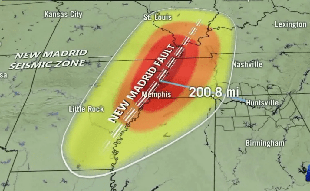
The catastrophic damage that the south has received is unprecedented. However, as Jesus warned in Matthew Chapter 24, the world would begin to see and experience unprecedented natural disasters that would be sent to warn mankind of GOD’s Divine rule and mercy of drawing people back to him.
Situated in the southern part of the United States, and inactive for nearly 212 years is the New Madrid Fault line. The NMSZ is responsible for the 1811–12 New Madrid earthquakes, which were a series of over 2,000 seismic events that lasted for about five months. The earthquakes were felt throughout the eastern United States and Canada and were believed to have magnitudes of approximately 8.0 or greater.
The south has not been hit with type of disaster for over 200 years. Affected by this potential disaster and what sits right on top of the fault line is Memphis, Tennessee, The Blue Ridge Mountains on the western half of Tennessee and other major cities in the south that obviously would be decimated with a 8.0 or higher earthquake. There is broad agreement in the scientific community that a continuing concern exists for a major destructive earthquake in the New Madrid seismic zone. Many structures in Memphis, Tenn., St. Louis, Mo., and other communities in the central Mississippi River Valley region are vulnerable and at risk from severe ground shaking. This assessment is based on decades of research on New Madrid earthquakes and related phenomena by dozens of Federal, university, State, and consulting earth scientists.
Considerable interest has developed recently from media reports that the New Madrid seismic zone may be shutting down. These reports stem from published research using global positioning system (GPS) instruments with results of geodetic measurements of strain in the Earth’s crust. Because of a lack of measurable strain at the surface in some areas of the seismic zone over the past 14 years, arguments have been advanced that there is no buildup of stress at depth within the New Madrid seismic zone and that the zone may no longer pose a significant hazard.
As part of the consensus-building process used to develop the national seismic hazard maps, the U.S. Geological Survey (USGS) convened a workshop of experts in 2006 to evaluate the latest findings in earthquake hazards in the Eastern United States. These experts considered the GPS data from New Madrid available at that time that also showed little to no ground movement at the surface. The experts did not find the GPS data to be a convincing reason to lower the assessment of earthquake hazard in the New Madrid region, especially in light of the many other types of data that are used to construct the hazard assessment, several of which are described here.

Podcast: Play in new window | Download


